What if one of the largest creatures in the sea left behind a digital trail so detailed, it could change how countries protect oceans? That’s exactly what’s happening with a giant manta ray whose movements are now verified by hard data—and the results are shaking up science and conservation alike.
A legend with wings becomes a fact you can trace
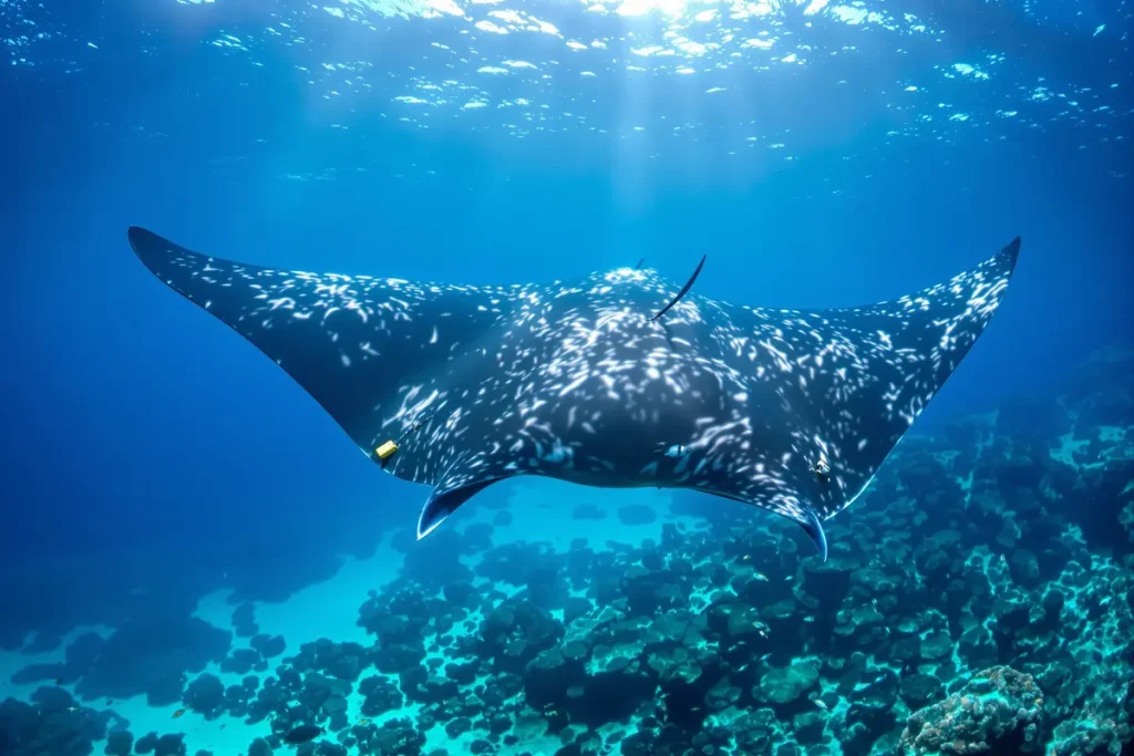
For years, this giant manta ray existed mostly as rumor. Divers across the Indian Ocean told tales of a massive female, wider than a van, appearing briefly before vanishing like a ghost. All of that changed the moment scientists managed to fit her with a satellite tag.
That small device—no bigger than a candy bar—attached near her dorsal fin and started recording her depth, temperature, and location. Anytime she came near the surface, it beamed that data to satellites above. She now had a digital ID code. A track. A story told in numbers, not guesses.
Over 1,000 kilometers in weeks—and dangers mapped along the way
One part of her journey left researchers stunned. Over several weeks, she swam more than 1,000 kilometers, crossing waters of at least three countries. She followed hidden underwater mountains (called seamounts), visited cleaning stations used by local fish, and then dove to nearly 600 meters before returning to a known reef.
Every belly spot captured by divers confirmed it: this was the same ray. Her route passed through fishing zones, shipping lanes, and tourist hotspots—places full of risks few had understood before.
Why verified data changes the rules
Until recently, most protections for species like manta rays were based on seasonal trends, not facts. But now, with this level of precise tracking, scientists and governments can act on truths you can’t argue with. The manta’s path shows where she’s at risk and when she needs space.
For example, her track overlapped with busy regions where slow-speed zones for boats might become law. That’s all thanks to data collected from one individual that reveals much larger patterns.
How does tagging actually work?
It sounds high-tech, but the process is surprisingly simple and gentle. When the team spots a likely ray—calm, large, and close—a diver slips into the water and positions a pole holding the tag. With one careful touch near the base of the dorsal fin, the tag anchors to the upper skin. No nets, no chasing.
Once tagged, the manta swims off almost instantly. Most return to normal behavior within minutes. The tags are designed to fall off naturally after weeks or months, leaving barely a scar.
Turning numbers into conservation tools
Each dot on the manta’s migration map stands for effort: crews replacing receivers, graduate students cleaning messy data, boat captains reporting sightings. It isn’t glamorous. But that dedication paid off.
Thanks to this detailed record, marine park teams can argue for rules that reflect the manta’s real needs—not guesses or averages. Tour operators are also adjusting schedules to give manta rays more peaceful time at cleaning stations.
So why does this matter to you?
Even if you never dive, this story touches you. Data from this ray is already part of talks on high-seas law, offshore wind farms, and shipping regulations. When someone says, “wildlife won’t be affected here,” scientists can now prove otherwise—with maps and timestamps.
And for those who do dive? This information shows the best times and places to respectfully meet manta rays. It helps avoid disturbing them and supports local guides who care about the ocean.
Key facts from the giant manta ray’s digital trail
- Track distance: Over 1,000 km journey across at least 3 countries
- Usual depth at cleaning stations: 10–30 meters
- Deep dives: Up to 600 meters for feeding
- Tag size: Comparable to a candy bar
- Wingspan: Estimated between 6 and 7 meters
- Behavior after tagging: Resumes normal swimming within minutes
Frequently Asked Questions
How big was the manta ray?
Divers and lasers estimate she measured 6–7 meters wide—among the largest known in the Indo-Pacific.
Does the tag hurt her?
Not at all. Tags attach securely to the upper skin, not muscle. They’re designed to shed over time and cause no long-term harm.
Can divers help researchers?
Yes. Divers who upload clear belly photos help scientists confirm manta identities between satellite check-ins.
Why is this data important?
It shows exactly where and when manta rays need protection, helping shape better, smarter marine policies.
Is this just for mantas?
No. Similar tagging works with whales, sharks, turtles, and tuna. But manta rays are ideal ambassadors because each one has a visible, unique “fingerprint” pattern.
A final thought
The last ping from the satellite tag isn’t a period; it’s a comma. Somewhere out there, this giant manta ray still glides through oceans we only just started to understand. Thanks to the tag, her story becomes part of our maps, our rules, our choices.
It’s easy to dismiss data as just numbers. But these numbers bring the deep blue ocean to our fingertips—and remind us that protecting it starts with knowing it better.